Why Rivers Make Useful Clues to a Region's Shape
Learn how to read rivers as clues to a region’s shape by tracing tributaries, ridges and crossings on a map, and see how the land connects settlements.
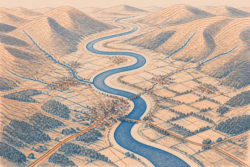
Why does a river bend, gather smaller streams and pass through some settlements but not others? Reading rivers as clues to a region’s shape starts with the land around them: slopes and valleys guide water, while flatter ground can offer room for roads and buildings. A river can organise a landscape without marking every boundary within it.
Use a paper map or an online topographic map, where contour lines show changes in elevation. Read the river alongside nearby ridges, tributaries, routes and settlements. This is not a survey; it is a way to notice relationships that a river symbol alone cannot show.
Choose a stretch
Select a manageable section with a bend, a tributary or a change in valley width. A local map may show one near a town or footpath. Check the legend and choose a scale that includes both the watercourse and surrounding landforms.
Mark the river’s upstream and downstream directions, then note where smaller streams join it. Do not treat the water as a line dividing the map in half. Ask what terrain it follows and how nearby routes and settlements relate to it.
Read the valley
Inspect contour lines or shaded relief around the river. Contour lines that form curved shapes around lower ground can reveal a valley; their pattern helps you see how the land slopes. A narrow valley may have steep sides that constrain crossings and settlement. A wider valley may offer more room for fields, roads or buildings.
Compare the river’s course with ridges and higher ground. Streams generally follow lower land, while ridges separate the areas from which water drains. The land drained by a river and its tributaries is its catchment. The catchment’s outer edge is a watershed, usually following higher ground rather than the river itself.
Think of a river as a crease in a folded sheet of paper: it helps reveal the shape, but does not explain every fold around it. Nearby uplands can shape the region just as decisively as the valley.
Trace tributaries
Follow tributaries upstream on the map. Notice whether they join from one side or both, and whether their branches form a compact network or stretch across a broad area. The pattern shows how water gathers from slopes and valleys into a larger channel.
Then look at the network’s outline. Tributaries crossing a broad basin may connect places that share a drainage system, even if those places feel distinct in other ways. Steep ridges separating neighbouring streams may mark a division that the main river alone does not reveal.
Compare crossings
Note where roads, railways or paths cross the river. Several crossings near a settlement may indicate a useful connection point; long gaps may reflect a wide valley, limited routes or the way infrastructure is represented on the map. Treat each pattern as a question, not an explanation in itself.
Check whether routes follow the river, run along a valley edge or climb over higher ground. Their paths show how terrain can channel movement. A river may link places along its banks and still make a direct crossing difficult, so it can serve as both route and obstacle.
Compare the banks
Look for differences between the two banks. Settlements, roads and fields may be denser on one side because the opposite bank is steeper, wetter or less accessible. A map offers clues, but not necessarily the reason; compare land cover and elevation before drawing a conclusion.
Say a map shows a village on a gentle bend, a nearby road crossing and a tributary descending from higher ground. Mark those features, then compare them with the next settlement downstream. If that settlement lies on a wider valley floor, the contrast suggests that the river corridor offers different conditions at different points. It does not, by itself, establish why either settlement formed there.
Questions about rivers?
Does a river mark a region’s boundary?
Sometimes, but the river’s course does not establish a boundary by itself. A mapped boundary may follow the water, cross it or lie elsewhere, so read the boundary symbol separately.
What does a river bend tell me?
A bend shows the river’s path across the valley floor and may reflect how water reshapes its channel over time. Compare it with the valley’s width and nearby slopes rather than treating it as a boundary or settlement marker.
How do I find a watershed?
Look for higher ground separating streams that flow into different river systems. On a topographic map, trace ridges and compare the direction of nearby valleys; the watershed follows the divide, not the main channel.
Why do towns cluster near rivers?
Water, flatter ground and crossing points can make river valleys useful places for settlement and movement. The reason for any particular town’s location depends on local conditions, so compare its terrain and routes with nearby places.
Build a map sketch
Bring the observations together in a simple sketch. Draw the main channel, tributaries, ridges, settlements and crossings, then add arrows for the general direction of flow. Check those arrows against the contours and river network. Keep the sketch selective: its purpose is to show relationships, not reproduce every feature.
- Check the contour pattern around the channel; if it forms a narrow valley, mark the confined corridor, but if it opens out, mark the broader ground instead.
- Check where tributaries join the main river; if they converge from several slopes, show their shared drainage network, but if ridges separate them, mark the divides clearly.
- Check the map legend for boundary symbols; if a boundary follows the river, draw it separately from the channel, but if it crosses or avoids the river, preserve that distinction.
- Check the locations of roads, railways and paths; if they cross at a settlement, mark the crossing point, but if they follow the valley or avoid it, sketch their route without assuming why.
- Check the land on each bank; if one side appears steeper or more densely settled, record that contrast, but if the map gives no clear difference, leave the cause unresolved.
- Check the flow direction against tributaries and valley slopes; if both point towards the main channel’s downstream course, add an arrow, but if the map is unclear, leave the direction unmarked until it can be checked.
Now separate observations from explanations. “The valley narrows beside the road” is an observation; “the valley determined the road’s route” is a possible explanation that needs more context. This distinction keeps the map reading grounded without making the river responsible for every feature.
Reading rivers as clues to a region’s shape works best when you compare the channel with its catchment, ridges and routes. Keep boundary lines distinct from watercourses, and let the surrounding land show which connections are visible—and which explanations remain uncertain.