Regional Border or Local Boundary? What Changes on the Map
Learn how to read a regional border or local boundary on a map, identify the unit each line separates and choose a map suited to your question.
Does a line on a map show where a region ends, or which local authority covers an address? A regional border or local boundary can look much the same, but the mapped unit determines what the line can tell you. Start by asking what decision you need to make, then check whether the map identifies the boundary that answers it.
Two kinds of boundary
A regional border separates broad areas, such as counties, provinces or named geographic regions. A local boundary divides smaller units, such as municipalities, parishes or wards. A settlement may sit within both at once, just as a small box can sit inside a larger box.
These terms do not always describe the same kind of thing. An administrative boundary marks a defined governing or service area. A cultural or physical region may instead describe a shared landscape, history or identity; its edge might be interpreted differently on different maps.
Line weight alone cannot settle the distinction. A map-maker may draw a local boundary heavily to keep it legible, while a regional edge may be thin. The map’s purpose, legend and source are stronger clues.
Read the boundary evidence
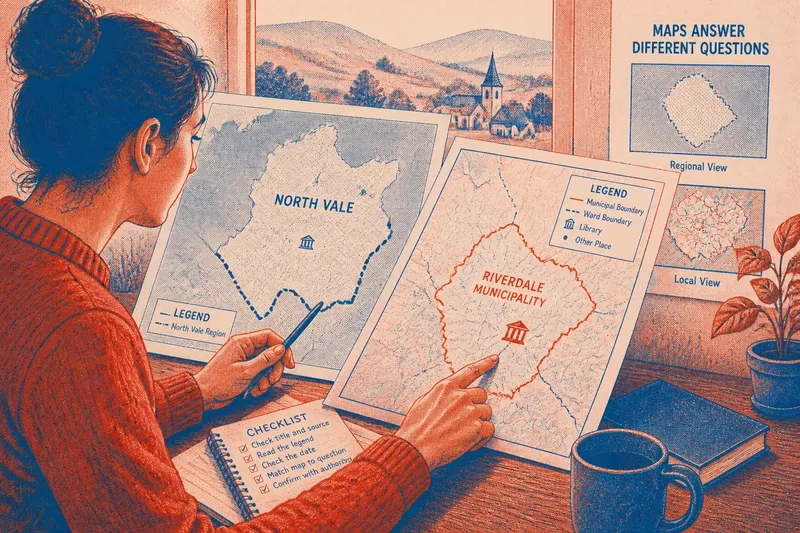
Check the title and map-maker first. An electoral map is built to show representation; a council map may focus on service areas; a regional atlas may group places for comparison. A line omitted from one of these maps may simply be outside its purpose.
Then find the legend entry that matches the line. Look for a named category such as county boundary, municipal limit or ward edge. If the map gives no matching symbol, do not assign the line a precise administrative meaning based only on its colour or pattern. Labels can help, but a place-name printed inside an area does not necessarily identify the line around it.
Check the map’s date as well. A boundary may have been revised, while a general map may not be intended as an up-to-date official record. If the answer affects an official service or designation, consult the responsible authority’s current map or documentation.
Questions about map lines?
Can a place belong to several areas?
Yes. A town can be inside a broad region, a municipality and a ward because each boundary describes a different division. Use the unit relevant to your question rather than treating one as the only valid label.
Why do maps disagree?
Maps may differ in date, scale, source or the kind of region they define. Compare their legends and stated purposes before deciding that one line is wrong.
Can a regional edge be informal?
Yes. A map may show a cultural or landscape region without claiming that it is an official administrative limit. Treat its edge as a mapping choice unless the source identifies a formal boundary.
Which map should I use for an address?
Choose a detailed map that names the specific local unit you need, such as a municipality or ward. If an official decision depends on the result, confirm it with the authority responsible for that boundary.
Choose a map by purpose
A regional map is useful for comparing broad areas, but it may simplify or omit local divisions. A detailed administrative map can show smaller units, though it may not explain the broader geographic context. A combined map can show both levels; check that its symbols distinguish them clearly.
For a careful reading, use this set of checks. Each observation points to a practical decision:
- If the title names a regional atlas or broad-area comparison, use it for regional relationships; if you need a local service area, switch to an administrative map.
- If the legend identifies the line as a county or regional border, treat it as that broad division; if the symbol is unexplained, do not infer the boundary type from its appearance.
- If the map names a ward or municipality beside the line, check that the legend links the name to that boundary; if it does not, seek a map that explicitly identifies the unit.
- If the map date is older than the record you need, use a current map from the responsible authority; if the date is suitable for your broad comparison, keep the map but avoid treating it as an official current record.
- If two lines meet or run close together, check whether their legend entries describe different units; if they do, read them separately rather than merging them into one boundary.
- If a place-name appears inside a shaded area but no edge is defined, treat the area as a mapped region rather than a confirmed administrative unit; if a formal edge matters, consult the relevant authority’s documentation.
Say you need to know whether a library is inside a particular municipality. Imagine the map in front of you is an invented regional map titled “North Vale and its surroundings”. Its legend names the North Vale region but shows no municipal limits; the library and the municipality both appear within the region’s outline. That evidence answers the broad regional question, but not which municipal authority covers the library. You switch to an invented current council map whose legend identifies municipal boundaries, locate the library symbol and trace the municipal line around it. In this invented situation, the library falls inside the named municipality, so that map answers the service-area question; the regional map remains useful only for showing the wider setting.
When boundaries overlap
Different boundary types can cross, meet or follow the same route for a stretch. That does not make them interchangeable: one may separate administrative units while another marks a region drawn for geographic or cultural interpretation. Read each line against its own legend entry.
Scale also affects what remains visible. A regional map may simplify a winding local edge or leave it out, while a street-level map can show more detail. A missing line on a small-scale map is not, by itself, evidence that the boundary does not exist.
For the search phrase regional border or local boundary, the useful distinction is not how a line looks but what kind of area it defines. Match the map’s source, date and boundary type to the question, and treat an unexplained line as uncertain rather than asking it to answer more than it shows.