Why Towns Rarely Grow Like a Diagram
Why towns rarely grow like a diagram: read street joins, market squares and railway edges to understand how distinct neighbourhoods took shape.
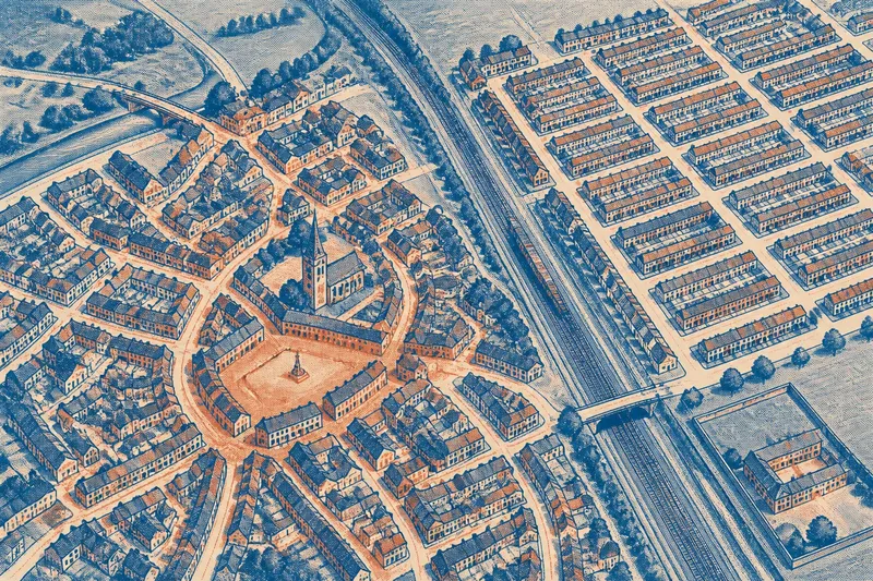
Why does a town’s neat street grid often stop short of its market square or railway? A town map can show how a planned district meets older lanes, a main road or a boundary, and those joins explain more than the grid alone. Town growth is rarely a single design copied across every neighbourhood.
Town street patterns
Begin with a detailed Ordnance Survey map or a local authority map that shows streets, place names and terrain. Find the most regular patch: parallel streets, repeated cross-street angles and similarly shaped blocks suggest a coordinated layout. Then compare it with the centre and the outer streets. A planned extension can sit beside an older cluster of lanes without changing their shape.
The junction between patterns is especially useful. A straight street may end at a curved lane; a square may interrupt the grid; or the blocks may suddenly become narrower. These are specific signs of adjoining layouts, not evidence that the entire town followed one plan.
Market and church centres
In some towns, streets gather around a market square, a church or a bridge. The approaches may arrive from different directions, while smaller lanes branch towards surrounding neighbourhoods. That arrangement differs from a grid, where streets tend to continue in parallel lines whether or not they lead to a central place.
Look at how the centre connects to the rest of the settlement. A market street that widens near a square may reflect the demands of trade and movement through the centre. A churchyard or other large plot can create a bend or gap in nearby streets. These relationships help explain the town’s shape without requiring one cause for every feature.
Railways and estate edges
Railways can divide a town into distinct street patterns. A new neighbourhood may have regular blocks on one side of the tracks, while older streets gather around a station or continue towards a level crossing. A railway cutting, embankment or station yard can also leave a sharp edge in the built-up area.
Large estates, school grounds and other broad properties may have a similar effect. If streets stop at a clear boundary, check whether the map shows a walled site, a railway corridor or a large institutional plot. The boundary may explain why streets turn or end there; it does not, by itself, establish when the neighbouring streets were built.
Roads through grids
A diagonal road crossing a regular district may have shaped the town before the grid arrived, or it may have been added later. Follow it beyond the built-up area: a route continuing towards a bridge, neighbouring settlement or main road connects the town to a wider network. Then inspect the junctions. If the grid bends around the route, the road may have constrained its layout; if the road cuts across blocks, it may have arrived after them.
Neither straightness nor curvature settles the question. A direct road can be new, and a winding street can follow a property line rather than an old route. Treat the connections and the way streets meet as more informative than shape alone.
What do town maps reveal?
Does a regular grid mean the whole town was planned?
No. Repeated blocks may mark one planned district within a town whose centre and edges developed differently. Compare the grid with the adjoining streets before describing the settlement as a whole.
Why might streets stop at a railway?
The tracks, embankment or station land may block direct continuation. Check whether streets resume beyond the railway or instead connect through a bridge or crossing.
What can a market square explain?
It can help explain why several streets converge or widen near the centre. Compare the approaches to the square with the more regular streets farther away to see whether the town has distinct patterns.
How can I tell whether a road came before a grid?
Look for a road that continues beyond the district and for grid streets that bend or end where they meet it. Those features suggest the route shaped the layout, but records are needed to establish its date.
Read one neighbourhood
Say you are examining an invented town map. The central streets form uneven loops around a market square; a railway lies to the east; and, beyond it, parallel roads form a regular group that stops at the tracks. First, note the market-centred loops and the repeated direction of the eastern streets. Next, trace the railway and mark where the regular pattern ends. The clearest reading is that the town has at least two distinct street patterns, with the railway separating the regular district from the centre. The map does not establish when either pattern formed or why the eastern layout was chosen.
For a town map, the most useful question is often not whether the settlement was planned, but where one pattern gives way to another. A market square, railway edge or estate boundary can make that change legible, much as a frame separates two pictures hung on the same wall. If you need to date a particular street, check local planning records or archives rather than inferring a date from its shape.